Town of Kill Devil Hills

Bulletin #6 from Dare County Emergency Management

Post Date: 08/21/2025 2:25 PM

Dare County Emergency Management Joint Information Center Header

View Bulletin #6

The National Weather Service office in Newport/Morehead City has advised that the highest water levels are expected to occur with this evening’s high tide, around 7 p.m., so remain vigilant until the storm moves further offshore. 

Areas north of Oregon Inlet are open to travel. Please keep in mind that conditions along the beach are extremely hazardous and are expected to deteriorate further as tides cycle and winds shift. 

Officials strongly urge the public to remain out of the water and to exercise extreme caution near the shoreline. The combination of heavy shore break, swift-moving water, and strong rip currents presents life-threatening conditions.

Tropical Storm and Storm Surge warnings remain in effect for Dare County, which also continues to operate under a State of Emergency. In addition, the Mandatory Evacuation order issued for all areas of Hatteras Island (Hurricane Evacuation Zone A) remains in effect until further notice.


View the latest weather briefing from the National Weather Service.

(Disclaimer: The information contained in the NWS briefings are time-sensitive. Note expiration time on briefing.)  

Photo of the Kill Devil Hills Town Hall

The Town of Kill Devil Hills has no significant damage to report thus far from Hurricane Erin. Staff remain prepared and continue to monitor the forecast and conditions closely.

At this time, we do not have any limitations as far as travel goes in Kill Devil Hills. However, any plans to visit the Outer Banks should be confirmed with your accommodations provider/property management company before departure. Please refer to drivenc.gov to check on local road conditions prior to traveling. 


Photo of double red flags flying at the beach to indicate no swimming is permitted.

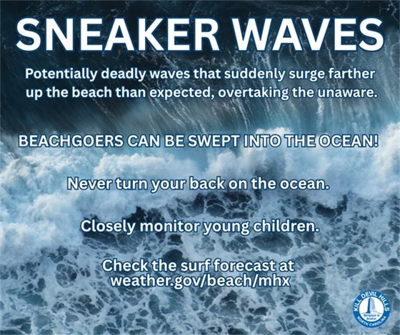
Don't risk your life or someone else's. 

Stay safe, stay out of the ocean!

Ocean conditions continue to worsen, especially around high tide, and the surf zone is extremely hazardous. We cannot stress this enough: it is not safe to be in the ocean, near the waterline, or even walking on the beach.

We know many people are curious and want to get out to take a look or snap photos, but this is not the time. Large and powerful waves are crashing into the shore with very little time between sets. The water isn't completely receding before the next wave hits, creating dangerous surges that can easily knock you down or sweep you into the ocean—even if you're just walking along the sand.

Please don’t take unnecessary risks. The combination of heavy shore break, fast-moving water, and strong rip currents makes this a life-threatening environment.

As the tides continue to cycle, conditions will become more dangerous into the afternoon/evening hours. 

Infographic with information on sneaker waves

Q: What is a rip current?

A: Rip currents are powerful, channeled currents of water flowing away from shore. They typically extend from the shoreline, through the surf zone, and past the line of breaking waves.

Certain wave, tide and beach shape conditions can increase rip currents to dangerous speeds. People get in trouble when they are moved so far offshore that they are unable to get back to the beach because of fear, panic, exhaustion or inefficient swimming skills. (Rip currents pull you out, not under.)

If you're caught in a rip current:

  • Remain calm.
  • Yell and wave for help.
  • Stay afloat.
  • Swim parallel to the shore. Don’t try to swim against the current.
  • Once you no longer feel the pull of the current, then you can begin swimming to shore.  

Text OBXBEACHCONDITIONS to 77295 to sign up for Outer Banks

 beach-related weather and ocean condition alerts. 


Monitor Storm Surge & Rising Water Levels: Never underestimate the force of water. Even a few feet of water can be life-threatening. Don’t attempt to drive or walk through flooded areas. Turn around, don’t drown! Sign up to receive alerts if water levels in your area begin to rise due to storm surge by visiting https://fiman.nc.gov/.

Safety Tips about staying out of flood waters

For current road conditions from NCDOT, visit drivenc.gov 

or follow NCDOT on Twitter or Facebook.  

Flood safety graphic: turn around, don't drown! Never walk or drive through flood waters.


Sign up to receive emergency alert notifications from the Town and county

Stay Informed

If you live, work, or visit Kill Devil Hills or Dare County, sign up for official emergency alerts: www.OBXAlerts.com

Stay informed and follow guidance from trusted sources: 

  • US National Weather Service Newport/Morehead City NC
  • NOAA NWS National Hurricane Center
  • NC Emergency Management
  • Dare County Government
  • Town of Kill Devil Hills

Additionally, for your safety, it's important to have multiple ways to receive warnings. Make sure at least one can wake you up! 

Photo of KDH Weather Station located at the former fire dept.

Did you know that the Town maintains a weather station (courtesy of the KDHFD Auxiliary)? It's located at our old fire station and it provides live data to the public. 

Stay informed with up-to-date “local as it gets” weather information from Fire Station 14.

Share on Facebook
Share on Twitter
Share via Email

Copyright © 2025 Kill Devil Hills. All Rights Reserved.
102 Town Hall Drive Kill Devil Hills, NC 27948; Phone: 252-449-5300; Email: rachel@kdhnc.com

Powered by
CivicSend - A product of CivicPlus